
Intelli Networks Infra Private Limited provides numerous GIS services to its clients all over the world. The GIS services rendered by Intelli Networks Infra Private Limited allow for the visualization of geographic data, analysis of spatial relationships, and efficient data management. The GIS data conversions allow data from different sources to be merged in one common format, which allows for easy access, analysis and utilization.
Intelli Networks Infra Private Limited works on GIS data conversions and prepares electronic maps using Geographic Information Systems (GIS) technology by utilizing the paper or electronic data that has been either captured by the clients or collected otherwise.
The vast expertise and experience allows Intelli Networks Infra Private Limited to integrate GIS, CAD and Global Positioning Systems (GPS) services, by using high-end GIS Mapping and GIS data conversions software. These services assist the customers to produce contour maps, spatial maps, atlas maps, cadastral maps, thematic and zonal maps, landscape maps, and environmental maps for host industries such as mining and geology, utility, agriculture, petroleum pipelines, land information management, and other GIS Mapping companies and Remote Sensing companies.
Intelli Networks Infra Private Limited provides GIS services with an all-inclusive solution for spatial data management to government and industrial organizations through GIS remote sensing services. Intelli Networks Infra Private Limited’s complex GIS Mapping Services and GIS Remote Sensing services include capturing, storing, integrating, manipulating, analysing, and displaying data related to positions on the Earth’s surface.
Intelli Networks Infra Private Limited uses updated technology, research and innovation that are implemented by highly experienced and qualified staff to create maps. Intelli Networks Infra Private Limited’s team of engineers, geo-scientists, planners have developed GIS products and systems, integrated with GPS, GIS, and CAD. The services can be used for system design and architecture, management and maintenance, map production and analysis (specialized for GIS mapping agencies also), database design and development, user training and support, and 3d modeling and visualization for GIS mapping products and GIS remote sensing products.
The various digitization services
Digitization services involve converting any physical document into a digital file. This ensures easy handling, sharing and editing of the document. Digitization services are used for converting maps, sketches, schematic diagrams, or circuit diagrams. They are known for ensuring positional accuracy of the objects and is therefore useful in many industries. Digitization services are also used in contour maps, topographic maps, zonal maps, cadastral maps, and utility maps.
Intelli Networks Infra Private Limited offers digitization services such as complete CAD Conversion, paper to CAD Conversions and CAD Drafting. These Digitization services are rendered using global standards and therefore the resulting products have high precision and quality. The digitization services at Intelli Networks Infra Private Limited seamlessly convert paper drawings and maps into highly accurate digital files, with the help of paper to CAD conversions.
The various digitization services
- 2D and 3D Digitization
- Paper to CAD Conversion
- Raster to Vector Conversion
Navigation
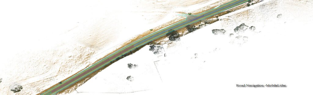
Navigation mapping assists the navigation content providers using GIS, GPS, and Remote sensing technologies instead of traditional method of manual assimilation of data for generation of navigation content. The accuracy of the new technology ensures creation of flawless maps. The rampant increase in the number of people who use computerised navigational services for everyday use. This trend has led to the development of new and innovative geodata content services and products.
Intelli Networks Infra Private Limited offers mapping of:
- Street and road network
- Point of interest
- 2D Landmarks
- 2D footprints
- 3D city models
- Indoor Building Maps
- Street Digitization
- 3D Building Landmarks
The maps are created while paying attention to details such as grid alignment, capturing dimensions accurately, positional accuracy and completeness of content. The data can be provided on multiple platforms.
Intelli Networks Infra Private Limited uses high end software such as ArcGIS, ERDAS Imagine / ER Mapper, MapInfo and AutoCAD Map to generate the final product in varied formats according to the project’s requirements.
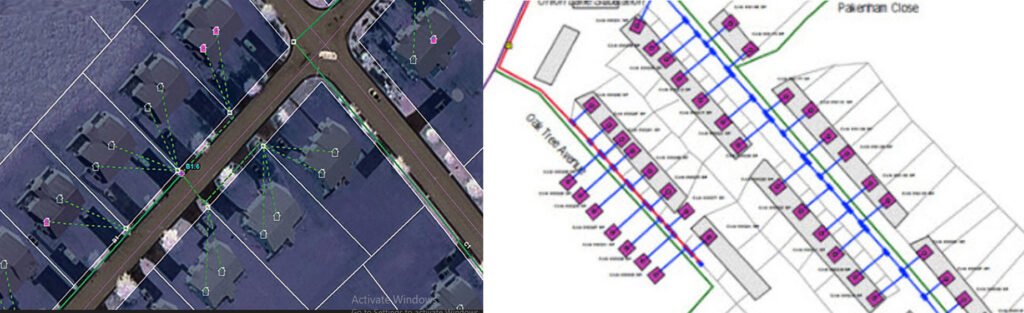
Municipal GIS
Intelli Networks Infra Private Limited has been working with the local and national governmental organisations for a long time now and understands the uniqueness and confidentiality of governmental work.
Many government aided bodies are recurring clients of Intelli Networks Infra Private Limited, as Intelli Networks Infra Private Limited provides a unique platform for generating timely and cost effective deliverables. The work involves GIS services such as georeferencing, satellite image processing, image classification, digitization, attribution, theme creation, map preparation, data analysis and report generation, computer aided designing and drafting services and remote sensing services. The client’s requirements are paid utmost attention and the work is done in close co-ordination with the client.
A municipal GIS system is a GIS system which manages various tasks of a municipality such as property tax, birth and death registration, socio economic data management and holding registration amongst other tasks. The municipal GIS service also assists in generation of a geospatial view of the current municipal area linked with the corresponding up-to-dated database.
The databases ideally possess attributes of every individual property with information such as land owner, co-owner, mailing & permanent address, house style, built year, individual room measurements, compliance with the regulations of the building authorities, public / private utilities mapping to the plot, street characteristics and amenities. There can also be a provision of linking every individual plots with their digital photographs, and a link to the map showing the location of the plot.
A municipal GIS System involves several steps including:
- Computerization of land records
- Digitization of existing spatial entities such as base maps
- Updation of property records
- Property Tax Assessment
- Infrastructure database creation
- Survey of the individual properties
- Updation of the non-spatial database on a day to day citizen centric level
Urban Infrastructure planning, development and analysis for the future infrastructure requires a robust municipal GIS system in place. The generation of thematic map / zoning map created a high visual impact and is used for assessment of several sectors such as for water network planning, property mapping by assessor, snow plowing in temperate regions, maintenance of cities and civic amenities services, etc.
The updated spatial and non-spatial database on the Municipal GIS system helps the concerned municipality to export and print the generated maps for any specific usage by the concerned field officer, or the property owner at any point of time thereby saving cost and time.
A citizen centric service center is also organized wherein a daily updation of the spatial and non-spatial database is being taken care of, thereby keeping this Municipal GIS System in an updated position.
Cadastral Mapping
Cadastral mapping is a comprehensive register of the details related to the property of an area. These details include the precise location, dimensions, and other geographical classifications of the properties or individual parcels of land. The maps generated using cadastral mapping services help in effective management of public land records. National and local governmental bodies, architecture and engineering firms, real estate developers, industries can uses the cadastral mapping services for making well informed decisions. Cadastral mapping services also enable to user to study additional details, such as survey district names, unique identifying numbers for parcels, certificate of title numbers, positions of existing structures, section or lot numbers and their respective areas, adjoining street names, selected boundary dimensions and references to prior maps.
Intelli Networks Infra Private Limited provides cadastral mapping for creation of cadastral maps from hard copies of the administrative maps with specific details of each plot, roads, railway lines, water bodies, vegetation, etc. These cadastral mapping service provide all inclusive solutions to land information system problems by focusing on various forms of land records.
Parcel Mapping
Parcel Mapping is a process in which land parcels are created for efficient and effective land management. Parcel mapping service generates maps, created from base maps, with polygons that have details about the ownership of properties and other related information. The base maps used in parcel mapping are the cadastral maps showing each individual plots in different sub divisions. The land parcels are the fundamental data layer on which different data are referenced. Parcel mapping has a variety of uses such as land administration & property registration by urban and rural governing bodies. Municipality planning & urban development is taken care through the use of various parcel mapping techniques, which have the ability to restore analytical data that is crucial for enhancing the operational abilities of the government bodies.
Use of parcel mapping services has increased over time and it has been observed that the time required to process and fulfil requests for land registry information has dropped by almost 80% in various countries. The use of parcel mapping services has consequently led to substantial improvements in handling the enormous requests generated over a period. Subsequently there is a huge reduction of overhead costs, and maintaining the data in a secured environment. Parcel mapping is also used by cartographic officials, rescue operations during floods and natural disasters for identifying property owners and retrieving crucial data. Parcel maps are also the base for any such GIS Maps.
Intelli Networks Infra Private Limited can replace the cumbersome process of maintaining data on paper maps with digital parcel maps using parcel mapping for:
- Municipal & other Urban Bodies
- Government Departments
- Builders
- Real Estate Agents
- Appraisers
- Engineers
- Surveyors
- Developers
Data Migration
- Positional accuracy information
- Legacy to New spatial database
- Data Validation